搜索结果: 1-15 共查到“工学 rivers”相关记录28条 . 查询时间(0.078 秒)

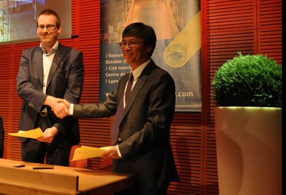
南京水利科学研究院成功申办2021年国际航运协会 第10届内河航运国际学术会议(Smart Rivers 2021)(图)
南京水利科学研究院 2021年 国际航运协会 第10届 内河航运国际学术会议
2019/10/29
2019年10月3日,在法国里昂举办的国际航运协会(PIANC)第9届内河航运国际学术会议(Smart Rivers 2019)的闭幕式上,李云副院长应邀作大会报告,详细展示了我国在内河航运领域取得的巨大成就、京杭大运河过去、现在和未来、长江黄金水道工程、长江经济带战略以及南京和我院作为申办Smart Rivers 2021举办地与单位的优势。我院申办得到了国际航运协会的支持,国际航运协会秘书长G...

南京水利科学研究院成功申办2021年国际航运协会第10届内河航运国际学术会议(Smart Rivers 2021)(图)
南京水利科学研究院 2021年 国际航运协会 第10届 内河航运国际学术会议
2019/11/5
2019年10月3日,在法国里昂举办的国际航运协会(PIANC)第9届内河航运国际学术会议(Smart Rivers 2019)的闭幕式上,李云副院长应邀作大会报告,详细展示了我国在内河航运领域取得的巨大成就、京杭大运河过去、现在和未来、长江黄金水道工程、长江经济带战略以及南京和我院作为申办Smart Rivers 2021举办地与单位的优势。
ACQUISION OF GEOMETRICAL DATA OF SMALL RIVERS WITH AN UNMANNED WATER VEHICLE
Unmanned Water Vehicle Multi-sensor Platform Mobile Mapping Lidar Echo Sounder Flash Flood
2018/6/5
Rivers with small- and medium-scaled catchments have been increasingly affected by extreme events, i.e. flash floods, in the last years. New methods to describe and predict these events are developed ...
Study:Mountaintop Coal Mining Causes Appalachian Rivers to Run ‘Consistently Saltier’
Mountaintop Coal Mining Appalachian Rivers Consistently Saltier
2017/7/25
Mountaintop-removal coal mining causes many streams and rivers in Appalachia to run consistently saltier for up to 80 percent of the year, a new study by researchers at the University of Wyoming and D...
OPTIMAL BAND RATIO ANALYSIS OF WORLDVIEW-3 IMAGERY FOR BATHYMETRY OF SHALLOW RIVERS (CASE STUDY:SARCA RIVER,ITALY)
Bathymetry River Optimal Band Ratio Analysis WorldView-3 GeoEye Spectral Bands
2016/11/30
The Optimal Band Ratio Analysis (OBRA) could be considered as an efficient technique for bathymetry from optical imagery due to its robustness on substrate variability. This point receives more attent...
REMOTE SENSING APPLICATION OF THE GEOPHYSICAL CHANGES IN THE COASTLINES AND RIVERS OF ZAMBALES,PHILIPPINES
Remote Sensing Accretion Erosion Geophysical changes Lahar
2016/11/30
Geophysical changes in river outlet, river upstream and coastlines near the rivers of Bucao and Santo Tomas in Zambales, Philippines were analyzed using the Google Earth’s historical satellite imageri...
MONITORING OF THE RIVERBEDS OF RIVERS DNIESTER AND TISZA OF THE CARPATHIAN REGION
Channel processes Monitoring Flooding Displacement of Channels Space images Topographic maps
2016/11/23
The paper analyses the causes of riverbed shifts of the rivers Dniester and Tisza of the Carpathian region. Among these reasons are mostly climate, physical and geographical, and anthropogenic factors...
APPLICATION FOR 3D SCENE UNDERSTANDING IN DETECTING DISCHARGE OF DOMESTICWASTE ALONG COMPLEX URBAN RIVERS
Scene Understanding Image Classification Co-Registration Urban Rivers Complex Terrain
2016/7/28
In our study we use 3D scene understanding to detect the discharge of domestic solid waste along an urban river. Solid waste found along the Ciliwung River in the neighbourhoods of Bukit Duri and Kamp...
On World Water Day,scientists peer into rivers to answer water availability questions
World Water Day scientists rivers to answer water availability questions
2016/3/28
The following is part nine in a series on the National Science Foundation's Critical Zone Observatories (CZO) Network.Parts one, two, three, four, five, six, seven&#...
REACH SCALE APPLICATION OF UAV+SFM METHOD IN SHALLOW RIVERS HYPERSPATIAL BATHYMETRY
UAV SfM Alarm River Hyperspatial Resolution Near-Census River Science Shallow Rivers Bathymetry
2016/1/15
Nowadays, rivers are impacted by different human activities and highly regulated. To rehabilitate these systems, spatial and process-based analyses of rivers are essential. Hydrodynamic models are sop...
Automatic Recognition of Rivers from LIDAR Data by Profile Factor
LiDAR Automatic river recognition Profile factor function Edge extraction Skeleton generation
2015/11/20
Laser infrared Detection and Ranging (LiDAR) has become one competitive remote sensing (RS) and photogrammetry technique. Extracting rivers’ distribution from LiDAR’s point cloud is one of its importa...
RECREATION AND SIMULATION OF PREINDUSTRIAL FLOUR PROCESSES IN THE MARGIN OF RIVERS
Cultural Heritage Augmented Reality Preindustrial activities Simulation of processes
2015/3/3
Manufacture and preindustrial activities have configured infrastructures and commercial development along several centuries. Both regional economic and social environment of the present days can be se...
Geospatial Modelling Approach for Interlinking of Rivers: A Case Study of Vamsadhara and Nagavali River Systems in Srikakulam, Andhra Pradesh
Geospatial Modelling Majority Rule Based (MRB) aggregation Analytical Hierarchy Process (AHP) based Multi-Criteria Decision Making (MCDM) Network Routing Interlinking of Rivers
2014/12/15
India is prone to several natural disasters such as floods, droughts, cyclones, landslides and earthquakes on account of its geoclimatic conditions. But the most frequent and prominent disasters are f...

In the Earth Surface Dynamics Lab at the California Institute of Technology (Caltech) the behavior of rivers is modeled through the use of artificial rivers—flumes—through which water can be pumped at...
MONITORING THE CHANGES OF LAKES IN THE SOURCE REGION OF THREE RIVERS WITH REMOTE SENSING DATA FROM 1976 TO 2009
Source Region of Three Rivers (SRTR) lakes’ change index of lake change trend (ILCT) remote sensing monitoring
2014/4/24
As the birthplace of Yangtze River, the Yellow River and Lancang Rive, Source Region of Three Rivers (SRTR) is an important
resource for fresh water supplement in China. SRTR also has very obvious e...

