搜索结果: 1-15 共查到“Mexico”相关记录343条 . 查询时间(0.078 秒)
UAV LiDAR Survey for Archaeological Documentation in Chiapas, Mexico
LiDAR UAV mapping archaeology Mesoamerica
2023/12/5
Airborne laser scanning has proven useful for rapid and extensive documentation of historic cultural landscapes after years of applications mapping natural landscapes and the built environment. The re...

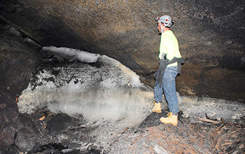
Geoscientists discover ancestral Puebloans survived on ice melt in New Mexico lava tubes(图)
Geoscientists ancestral Puebloans survived ice melt New Mexico lava tubes
2020/12/11
For more than 10,000 years, the people who lived on the arid landscape of modern-day western New Mexico were renowned for their complex societies, unique architecture and early economic and political ...

Researchers track nutrient transport in the Gulf of Mexico(图)
nutrient transport Gulf Mexico
2020/9/18
The Gulf of Mexico receives considerable levels of nutrients from the rivers that empty into it, especially the Mississippi River, causing the Gulf's northern waters to become overly enriched and more...
China’s Strategic Partnerships in Latin America: Case Studies of China’s Oil Diplomacy in Argentina, Brazil, Mexico, and Venezuela 1991–2015
Strategic Partnerships Latin America Argentina Brazil Mexico
2019/10/11
In 2011, the Peruvian drug czar appointed by incoming President Ollanta Humala announced that U.S.-supported coca eradication was suspended in favor of locally-based alternative development and target...
FLOOD VULNERABILITY REDUCTION, USING A PARTIAL PARTICIPATORY GIS APPROACH. A STUDY CASE IN BAJA CALIFORNIA SUR, MEXICO
Participatory cartography loods cyclones vulnerability reduction
2018/4/18
A partial participatory GIS approach was implemented in a community in La Paz, Baja California Sur, Mexico to reduce vulnerability of floods caused by cyclones. A workshop was held to locate areas sus...
FLOOD VULNERABILITY REDUCTION, USING A PARTIAL PARTICIPATORY GIS APPROACH. A STUDY CASE IN BAJA CALIFORNIA SUR, MEXICO.
Participatory cartography, floods, cyclones, vulnerability reduction
2018/5/8
A partial participatory GIS approach was implemented in a community in La Paz, Baja California Sur, Mexico to reduce vulnerability of floods caused by cyclones. A workshop was held to locate areas sus...
MOSAICKING MEXICO - THE BIG PICTURE OF BIG DATA
Mosaicking Geovisualization Color Balancing
2016/7/8
The project presented in this article is to create a completely seamless and cloud-free mosaic of Mexico at a resolution of 5m, using approximately 4,500 RapidEye images. To complete this project in a...
There is overwhelming evidence that riverine
nutrients drive both the production of
phytoplankton and the size of the hypoxic
zone on the inner shelf.
Characterization and long-term trends of hypoxia in the northern Gulf of Mexico: Does the science support the action plan?
long-term trends of hypoxia the northern Gulf of Mexico
2016/5/18
We update and reevaluate the scientific information on the distribution, history, and causes of continental
shelf hypoxia that supports the 2001 Action Plan for Reducing, Mitigating, and Controlling ...
mental benefit analysis” for making decisions
on the management of contaminated sites
within the DOE nuclear weapons complex.
We are not presently in a position to offer
critique or endorsement of...
Self-Medication and Health Insurance Coverage in Mexico
Self-medication Health insurance Mexico
2016/3/18
Self-medication is a common practice in many developing countries but little is known about its determinants. This study analyzes the factors that are associated with the use of self-medication in Mex...
The Impact of the PROGRESA/Oportunidades Conditional Cash Transfer Program on Health and Related Outcomes for the Aging in Mexico
Aging Conditional cash transfers Health Mexico
2016/3/18
Conditional cash transfer (CCT) programs link public transfers to human capital investment in hopes of alleviating current poverty and reducing its intergenerational transmission. Whereas nearly all s...
Mapping Giant Reed (Arundo donax) Infestations along the Texas–Mexico Portion of the Rio Grande with Aerial Photography
Invasive weed area estimation image classification maximum likelihood classifier
2015/12/26
Giant reed is an invasive weed throughout the southern half of the United States, with the densest stands growing along the coastal rivers of southern California and the Rio Grande in Texas. The objec...
Microarray gene expression profiles from mature gonad tissues of Atlantic bluefin tuna,Thunnus thynnus in the Gulf of Mexico
Microarray gene expression profiles mature gonad tissues of Atlantic bluefin tuna Thunnus thynnus Gulf of Mexico
2015/11/16
Background: Bluefin tunas are highly prized pelagic fish species representing a significant economic resource to fisheries throughout the world. Atlantic bluefin tuna (Thunnus thynnus) populations hav...
Strategic Actions to Value, Conserve, and Restore the Natural Capital of Megadiversity Countries: The Case of Mexico
ecosystem assessment, science–policy gaps
2015/11/13
Decisionmakers need updated, scientifically sound and relevant information to implement appropriate policy measures and make innovative
commitments to halt biodiversity loss and improve human well-b...

